Safer routes to school
STAG are concerned with safety on the roads around the school. They worked with the local Neighbourhood Partnership and Bristol's Road Safety department to try to improve the road crossings and reduce the risk of accidents.
Five Minute Walk Zone
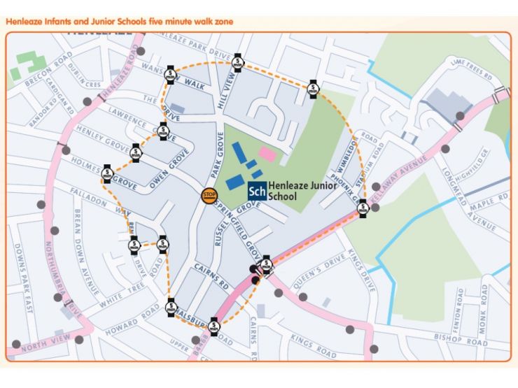
Children have helped STAG calculate how far you can walk away from the school in 5 minutes in every direction. using this information, the Council have produced a 5 minute Walk Zone map (above). Whilst we would love everybody to walk, cycle or scoot to school, we accept that some parents have to drive. We encourage them to park further away from the school to reduce congestion outside the school gates. If children walk just the last 5 minutes, not only are we all safer, but they are also healthier.
Plan your journey to school
Our friends at Bristol City Council produced a map of the area showing you just how close you live to the school.
If you live a little bit further away, or if you need to use the car to go on to work after dropping off at school, why not park a few streets away and walk the last bit? Park Grove gets very congested as it is a narrow street, and parked cars make crossing the road dangerous.
We would love more people to cycle to school. Mr Barber cycles nearly every day: if he can do it, so can you!
The Travel Plan
We wrote the plan a few years ago - you can find the original document below.
We monitor the plan regularly - there has been a small increase in the number of walkers and a larger increase in cycling since we became a Bike Champion School, but there are still too many car journeys clogging up the roads.
Parents hub
Minutes of STAG Meetings
- 10th November 2015
206.45 KB PDF Download
- STAG - 7th March 2017 meeting
74.28 KB PDF Download